
A record of Hiroshima's devastation
Spreading out before Shigeo Hayashi was an eerily silent plain of rubble, and yet, in his mindユs eye he saw the horrific scenes of the bombing.
"Every few steps I saw the remains of another makeshift crematoria. Wherever I aimed the camera, voices from the hell of two months earlier flooded toward me."
Hayashi started his picture taking at the hypocenter and gradually moved toward the outer edges of the ring.
|
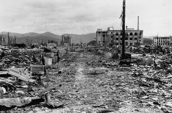
Looking northwest from the Shioya-cho area Location: Shioya-cho (now, Ote-machi 2 chome) |
Formerly a financial strip of banks and insurance companies, Ote-machi road is shown with its Ujina streetcar line. Many of these ferro-concrete and brick buildings were repaired and used after the war, then later demolished. From left: Hiroshima Gas Company, Hiroshima Banker's Club, Nippon Life Insurance Company Hiroshima Branch, Sanwa Bank Hiroshima Branch, Norinchukin Bank Hiroshima Branch, Mitsui & Co., LTD. Hiroshima Office, and Chiyoda Life Insurance Company Hiroshima Branch. |
|
|
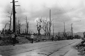
From Aioi Bridge Location: Center of Aioi Bridge |
The bridge built in 1932 took on a "T" shape two years later when it extended an arm to the "nose" of Jisenji Temple on the north tip of Nakajima-hon-machi. It was because of this unusual shape that it was chosen as the target of the atomic bombing. Immediately after the bombing, the bridge was strewn with charred humans and horses. The floating corpses were enough to smother the river. In these photos taken two months later, we sense calm in the people walking back and forth. |
|
 Looking east from Sarugaku-cho street Location: Sarugaku-cho (now, Ote-machi 1 chome) Sarugaku-cho Street was directly under the point of explosion. All houses and stores in the area were crushed and thoroughly consumed by fire, with the road only vaguely indicated by the line of concrete fire cisterns. Because the blast hit the cisterns from directly above, it blew out their bottoms. Countless people perished in the vicinity. The building to the far right is Yasuda Life Insurance Company. Chiyoda Life Insurance Company is the closest building; the Geibi Bank (now, Hiroshima Bank) stands behind it. The new Fukuya Department Store stands on the left (north) side of the street. |
 Looking east along the streetcar street from Sarugaku-cho Location: Sarugaku-cho (now, Ote-machi 1 chome) The streetcar street that ran east and west through the city center is the current Aioi-dori Avenue. On the rise of land to the left are the ruins of turret No. 1 on what had been the outer moat of Hiroshima Castle. The photo shows someone shouldering large belongings and others who have loaded their household possessions onto large carts or trucks. |
Looking northeast from the ruins of the Hiroshima Castle tower Location: Moto-machi |
 |
|
The view is northeast from the crumbled castle tower. Countless people plunged into this inner moat to escape the flames and died there. On the far side of the wooden bridge over the moat is the Hiroshima Army Elementary schoolyard. To its right are the still intact walls of the school. In the background stands the camouflaged Hiroshima Communications Bureau. |
 Looking from the Ninomaru gate toward the Honmaru (main castle compound) of Hiroshima Castle. Location: Moto-machi The wall in the foreground is the wall of the second bailey (ninomaru). On the lower level of the main compound in the background was the partially underground Chugoku Regional Military Headquarters Air Defense Office. Two girl students working as radio operators at the time were the first to report the bombing. |
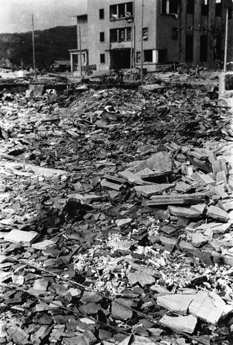 Remains of victims in the Sarugaku-cho area Location: Sarugaku-cho (now, Ote-machi 1 chome) Wooden houses packed tightly in the hypocenter area were enveloped and wholly swallowed by flames. Finely splintered human bone remained in the area. The physics sub-team collected human bone to calculate the phosphorus activated by neutron rays. |
|
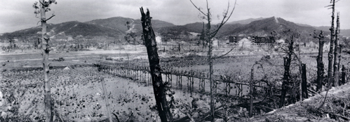
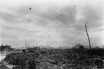 Looking south from Nakajima-hon-machi Location: Nakajima-hon-machi (now, Nakajima-cho) The ruins of Nakajima-hon-machi and Zaimoku-cho are where Peace Memorial Park now stands. From the late feudal era through the Meiji and early Taisho periods (the latter 19th to the early 20th century), Nakajima-hon-machi was the city's bustling shopping and entertainment center. Few structures remained between this point and the sea to block the view of Kanawajima Island, Etajima Island, and Ninoshima Island. |
|
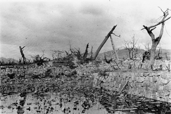
Looking east from the approach to Hiroshima Gokoku Shrine Location: Moto-machi |
A 180-degree panoramic shot facing east from just north of where Hiroshima Municipal Baseball Stadium stands today. The hypocenter is to the right of the shrine approach. To the left lie the ruins of Annex One of Hiroshima First Army Hospital. The ravaged willow trees attest to the violence of the blast. |
|