
A record of Hiroshima's devastation
Shigeo Hayashi had experienced the Tokyo Raids, losing his house to one of them. He had witnessed countless scenes of urban areas burned out by incendiary bombs, but when he swept his eyes over the whole of Hiroshima, words failed him.
"One bomb really did all this?"
When Hayashi was able to return to the task at hand, he positioned his camera.
|
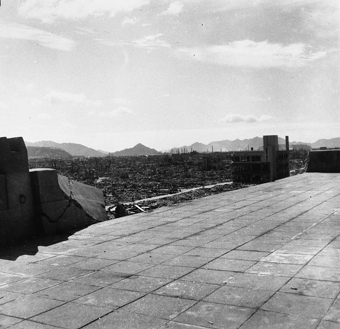
From the roof of new Chugoku Shimbun building Location: Kami-Nagarekawa-cho (now, Ebisu-cho) |
Panoramic photos from the new Chugoku Shimbun building that stood where Mitsukoshi Department Store stands now. From the observation room on the roof, one could see the entire city, the Chugoku mountain range and surrounding islands. That entire landscape was transformed on August 6. |
|
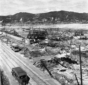
 Looking northwest from the roof of Shokochukin Bank Location: Higashi-uoya-cho (now, Tate-machi) This shot looks down on what is now the area in front of the Tate-machi streetcar stop. The building burned down to its iron framework is the forge workshop connected to the Municipal Waterworks Bureau Moto-machi Building. Wooden government buildings and storehouses burned to the ground. The staff in them died. A coal-burning bus appears in the foreground. An exposed streetcar is abandoned on the side of the road. |
 Looking southeast from the roof of Shokochukin Bank Location: Higashi-uoya-cho (now, Tate-machi) The blast tore off the wall around the roof. The whitish strip parallel to the roof line is Kinzagai Street. The three-story building remaining erect is Kirin Beer Hall. In the distance, Kanawajima Island is clearly outlined. |