
Annihilation of Hiroshima |
||
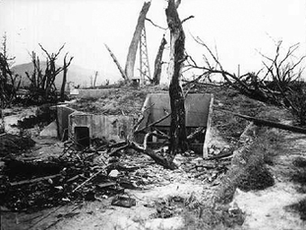 Near the entrance to the stricken Air Defense Room. Around November 1945. Taken by U.S. Army 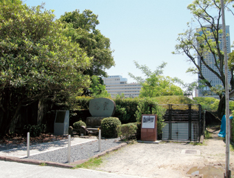 Corner of Hiroshima Castle, now east side of the Gokoku Shrine.
 The entrance to the semi-underground former Air Defense Room was on the other side of the fence. May 2008. |
Ruins of Chugoku Regional Military Headquarters Air Defense Room
The Hiroshima Castle area in Moto-machi was a concentration of Army facilities. At the Chugoku Regional Military Headquarters, which were located in the lower section of the castle keep, third-year students from Hijiyama Girls High School were mobilized as a Student Communications Squadron. Here, more than 700 Headquarters employees, 64 Hijiyama Girls High School students and teachers, and two prisoners from the U.S. military died. Yoshie Oka (then, 14), a student at Hijiyama Girls High School, was working in the Chugoku Regional Military Headquarters Air Defense Room as part of the student mobilization. Oka, who was in the semi-underground Defense Room when the bomb was dropped, lost consciousness for a while, then went outside. She was shocked to see a flattened Hiroshima, allowing her to see all the way to the sea. Returning to the Defense Room, she contacted Fukuyama with the news of Hiroshima’s destruction. This is said to have been the "initial report" from Hiroshima. 
* Location: 21 Moto-machi, Naka-ku * Distance from hypocenter: 790 meters * Name at time of bombing: Chugoku Regional Military Headquarters Air Defense Room * Structure/number of stories: Reinforced concrete, one story, semi-underground * Completed: Unknown * Name when completed: Chugoku Regional Military Headquarters Air Defense Room * Current status: Closed (open to peace study groups). |
|
Surviving at the Hypocenter |
||
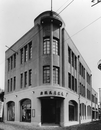 |
Rest House in Peace Memorial Park
The former Nakajima District, which today is Peace Memorial Park, was a prominent business quarter of the city during the early years of the Showa period (1926-1989). The Nakajima District had been the site of many wooden two-story structures. But in 1929, the three-story Taishoya Kimono Shop was constructed. It was said that if you went up to the roof, a panoramic view of the city awaited. In 1943 the Kimono Shop was closed and became the Fuel Hall. At the time of the bombing, 37 people were working there. All of them perished, with the exception of a single person who had gone down to the basement at that moment to retrieve some documents and miraculously survived. Although the building was heavily damaged, it was repaired early after the war, including being given a new wooden roof. After the war, the Hiroshima city government purchased the building and established a postwar recovery office in it. Today it is used as the Rest House in Peace Memorial Park. Shortly after the Taishoya Kimono Shop had been constructed, from the northwest corner (Children’s Peace Monument-side). March 1929. Courtesy of Shimizu Corporation Hiroshima Branch 
* Location: 1-1 Nakajima-cho, Naka-ku * Distance from hypocenter: 170 meters * Name at time of bombing: Fuel Hall * Structure/number of stories: Reinforced concrete, three stories with basement floor * Completed: 1929 * Name when completed: Taishoya Kimono Shop * Current status: First floor: Rest House in Peace Memorial Park. Second/third floors: Offices. Basement: Preserved nearly as it was at the time of the bombing. Can visit with advance notice. |
|
Lifesaving Bridges |
||
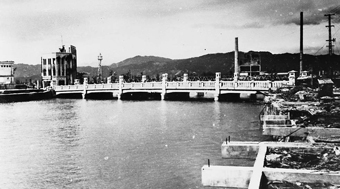 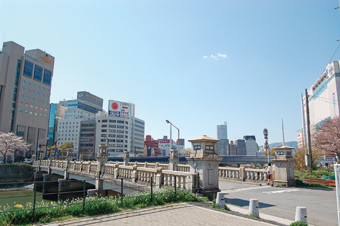 |
Enko Bridge
When it was built in 1926, the Enko was a bustling, magnificent bridge. The main columns featured dramatic lighting and eagles flapping their wings on top of a globe, while the railings were decorated with monkeys. These items were confiscated by the government during the war; and the bridge was converted to main columns and parapet walls of stone, which have lasted to this day. Although the atomic bomb damaged parts of the walls, structural damage was slight, enabling thousands to use the bridge as an escape route. [above] Around November 1945. Taken by U.S. Army [below] From the east end. Ekimae-ohashi Bridge now located about 60 meters north of Enko Bridge. The white building on right edge of the photo is "Yale Yale A" (department store). April 2008. 
* River name/Right bank/Left bank: Enkogawa River, 1-chome Matoba-cho, Minami-ku; Enkobashi-cho, Minami-ku * Distance from hypocenter: 1,820 meters * Name at time of bombing: Enko Bridge * Structure: Reinforced-concrete girders * Completed: 1926 * Name when completed: Enko Bridge * Current status: Same as at time of bombing, with parapet wall |
|